5/24/15
The history below is from the Ridge Route web site.
What is the Ridge Route?
“The Ridge Route Highway is that section of road that winds over the San Gabriel and Tehachapi Mountains between Castaic Junction on the south (where I-5 junctions with Hwy.126 to Ventura) and extends to the bottom of Grapevine Grade on the north where I-5 enters the great San Joaquin Valley.
The “Grapevine” is the 6 1/2 mile segment of the Ridge Route that extends from Fort Tejon to the bottom of Grapevine Grade. Many people erroneously believe that the “Grapevine” got its name because the original 1915 highway had a series of “switchbacks” which allowed early vehicles to gain elevation as they climbed the grade heading from Bakersfield toward Los Angeles. The serpentine path resembled a giant grapevine. Although this observation was true, the name actually came from the fact that early Wagoner’s had to hack their way through thick patches of Cimarron grapevines that inhabited “La Canada de Las Uvas,” Canyon of the Grapes. Traveling the grade today, look for patches of what appears to be ivy on both sides of the canyon near the truck run-a-way escape ramps. What you see are descendant vines which date back to the 1800s.
The news media Incorrectly refers to the entire Ridge Route as the Grapevine.
There have been (3) Ridge Route highways. The 1915 highway which is the focus of this web site; the 1933 three-lane Ridge Alternate Highway identified as Highway 99 (in 1947 converted to a 4-lane expressway); and today’s 8-lane I-5 freeway completed in 1970. The Ridge Alternate was severed with the construction of Pyramid Dam.”
Back in Spring 2005:
I had what my friend Otto would call ” One of Hans’ brilliant ideas” I laid out a route I would call the Wildflower Century. The plan was to ride road bikes from my house in Granada Hills to the Poppy reserve in the desert near Palmdale.
This was before we had such things as Map my ride and Strava where you can easily plan out a bike route and show distance and elevation. Back then it was maps and some guesswork. I figured we would do a loop through the Poppy Reserve and it would be around 105 miles. Part of the loop would take us on the Old Ridge Route which none of us had been on before.
I figured it was a chance to take in the history of this historic road. The problem was the road is not maintained and 2005 was an El Nino year. The heavy rains had washed out some of the road and many rocks, sand and mud had slid down onto the road. Not to mention my miscalculation of mileage!
Once we made our way onto the unmaintained section of road we already had 95 miles logged! We were still at least 35 miles from my house!
As we started the first downhill section the road became really rough and we started to get flat tires! We would repair the flat and keep on rolling. I don’t know how many flats we had but I can guess it was close to 10 flats between the three of us. The sun was setting and darkness was upon us before we knew it.
I decided to call Hope to bail us out! She agreed to help us so I gave her directions. In the meantime we kept riding slowly in the dark while fixing the occasion flat. About an hour later when we saw the lights of Hope’s car approaching we all felt relief. The road was very dark and Otto commented about how brave Hope was to make the drive on this isolated unmaintained road alone. We were lucky she did!
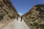
Since that ride I always wanted to go back and explore this road. When my buddy Bernie told me he was going to ride it I decided to join him. This time I would ride it on my mountain bike. Ed would also join us on his mountain bike and Bernie would ride his gravel bike which is basically a road bike with heavier duty tires and rims.
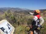
We started the ride in Castaic and would ride 26 miles to the Sandberg Inn site and then return the same way. The terrain was mostly climbing though we did have some downhill sections that we would have to climb on the return trip.
We had perfect weather with an average temperature of 70 degrees. The skies were clear offering us some outstanding views. The gate was open so we did see a few cars and motorcycles. I am not sure if the gate is always open or not? We also saw a few other cyclists.
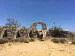
The road was in better shape this time around. The large landslides we had to hike around in 2005 had been repaired. It was nice to be able to take in this bit of history that I along with many other people have driven by on the 5 freeway just a mile or two away so many times before.
This time around we had zero flat tires and all went smoothly!